Bill Swanson looked down and saw treetops.
He was still aboard his fishing boat.
That required some explaining.
Badger had been anchored near the entrance of Lituya Bay on the evening of July 9, 1958, with Swanson and his wife Vivian aboard. A violent earthquake had begun a few minutes earlier. Now the boat was lodged near the crest of an enormous wave and moving stern-first across La Chaussee Spit, the wooded strip of land separating the sheltered bay from the Gulf of Alaska. Swanson later described looking down at the forest beneath him as the wave carried Badger over it.

The boat came down hard on the far side.
It foundered.
Bill and Vivian climbed into their little skiff wearing essentially what they had gone to bed in. They had no proper oar. The Alaska Earthquake Center’s reconstruction says they used a chair as a paddle while waiting in the disturbed water outside the bay.
A little after midnight, another fishing boat found them alive.
Two miles or so away, another couple was gone.
Three boats
Lituya Bay is an odd place even before the mountain falls into it.
The bay cuts about seven miles into the southeast Alaskan coast, narrow at the entrance and branching into two glacier-fed inlets at its head. Steep mountains rise almost directly from the water. The Fairweather Fault crosses the inlets. Tides at the entrance can make getting into or out of the bay difficult enough that fishermen normally time the passage carefully. For a long stretch of exposed Gulf of Alaska coastline, however, Lituya offers one of the few useful anchorages.

Three fishing boats were there that evening.
Bill and Vivian Swanson had Badger. Orville and Mickey Wagner were aboard Sunmore. Farther inside the bay, Howard Ulrich had anchored Edrie with his seven-year-old son. A group of mountaineers had been camping near the shore as well, but their pilot arrived a day early and flew them out around nine that evening.
The timing saved them.
At 10:16 p.m., roughly magnitude 7.8 shaking began along the Fairweather Fault. The rupture extended for about 125 miles through southeastern Alaska. Five people died in the wider earthquake, all in water-related incidents; three were lost near Yakutat when part of Khantaak Island collapsed, and the other two would be the Wagners aboard Sunmore.
In Lituya Bay, Ulrich went onto the deck.
Mountains were coming apart.
The first sound
The earthquake itself did not create the famous 1,720-foot mark by simply lifting the bay.
A massive rockslide fell into Gilbert Inlet at the head of Lituya Bay during the shaking. Modern USGS material treats that landslide impact as the generator of the extraordinary wave, although researchers have continued debating details of exactly how the energy moved through the inlet, glacier front, water and sediment.

Ulrich heard what the Alaska Earthquake Center describes as a great roar from the head of the bay.
Then the water rose.
The sequence is useful because it preserves what this looked like before anybody had the word megatsunami available as an explanation. Ulrich did not initially describe a conventional ocean wave rolling neatly out of Gilbert Inlet. He saw an explosive displacement of water around the glacier and mountains, followed by a large wave entering the main bay.
He had only a few minutes before it reached him.
The Wagners on Sunmore reacted first and started toward the entrance.
Ulrich tried to raise Edrie’s anchor.
It would not come.
The mountain mark
The figure everybody remembers came from the opposite wall of Gilbert Inlet.
The landslide plunged into deep water and drove water up the spur directly across from it. When USGS geologist Don Miller later surveyed the stripped mountainside, he measured the highest trimline at 1,720 feet above sea level. USGS still identifies it as the largest documented tsunami runup in the historical record.
That word matters.
Runup is the elevation water reaches as it climbs terrain.
It is not automatically the height of the traveling wave in open water.
The distinction has become badly blurred in popular retellings. “A 1,720-foot tsunami hit Alaska” sounds as if a wall more than a quarter-mile tall traveled down the entire bay.
It did not.
Modern USGS guidance describes a maximum runup of about 524 meters—1,719 to 1,720 feet depending on rounding—while the wave moving through Lituya Bay was on the order of 30 meters, roughly 100 feet.
A hundred-foot wave remains an inconvenient thing to encounter in a fishing boat.
Edrie
Ulrich could not free the anchor before the wave reached him.
He put a life preserver on his son, let out the remaining anchor chain and turned the boat toward the approaching water. As the wave lifted Edrie, the anchor chain snapped. The boat climbed the face, crossed the crest and came down the other side still upright, with its engine still running.
That outcome has sometimes been described as the boat “surfing” the largest wave ever recorded.
It is better to keep the geometry visible.
Edrie was not directly beneath the 1,720-foot runup site. By the time the disturbance crossed the bay to Ulrich’s anchorage, the travelling wave was dramatically smaller than the splash and runup at Gilbert Inlet, though still large enough to snap his anchor chain and move the vessel violently toward shore and back toward the center of the bay.
Then came the part that tends to vanish from short versions of the story.
The first wave did not leave flat water behind.
Ulrich had to maneuver Edrie through steep, chaotic waves reported up to around twenty feet high, mixed with uprooted timber and chunks of ice. The disturbance sloshed around the enclosed bay for roughly half an hour.
Eventually he got the boat through Lituya’s narrow entrance and out to sea.
Father and son were alive.
Badger
The Swansons were closer to the entrance.
Their boat received the wave differently.
Badger was picked up, driven toward La Chaussee Spit and carried across it. Swanson later remembered the boat moving backward near the crest, with the trees below him. The boat cleared the spit, came down on the Gulf side and began sinking.

That is where the title comes from.
Not from a metaphor.
The boat went over the trees.
Bill and Vivian escaped into their skiff. The boat that eventually picked them up did not enter Lituya Bay to do it. Ulrich had radioed outward after surviving the wave and warned another fisherman not to come through the entrance while the bay remained full of floating timber and violent water.
The Swansons waited outside.
They had already crossed the land once.
Sunmore
Orville and Mickey Wagner had tried to leave before the wave reached the outer bay.
They did not make it.
Sunmore disappeared with both of them. Their bodies were never recovered. USGS describes the vessel as the boat that was underway near the entrance when the wave struck and sank it.
There is a nasty little reversal in the three outcomes.
The boat that had already begun running for open water was lost.
The boat that could not retrieve its anchor rode over the wave.
The boat anchored near the entrance was thrown bodily across the spit, destroyed, and still left its crew alive.
That is not evidence for a survival rule.
It is evidence for how sensitive the outcome was to a few hundred yards of position, wave shape, boat orientation and timing.
Don Miller had been there before
One person who reached Lituya Bay after the disaster already knew that the place could produce impossible-looking water marks.
USGS geologist Don Miller had studied the bay during the 1950s. He had noticed older trimlines where younger vegetation below a distinct boundary suggested that earlier giant waves had stripped the shore. From tree ages and physical evidence, he identified earlier events in 1936, around 1874, and in the 1850s.
Before 1958, he did not know what had made them.
Then the earthquake happened while Miller was elsewhere in Glacier Bay.
He returned as quickly as he could.
The bay was so clogged with floating logs and ice that the initial aircraft could not land. From above, Miller saw the forest stripped from the slopes and a fresh scar above Gilbert Inlet. Part of the Lituya Glacier front had been sheared away. Opposite the landslide, clean bedrock extended upward to a height that looked absurd even from the airplane.
The first rough altimeter reading approached 1,800 feet.
Miller later measured the highest line more carefully.
1,720.
People did not believe him
The height caused a scientific problem.
Miller’s observations were doubted.
That is worth preserving because the current shorthand—“the largest wave ever recorded”—makes the measurement sound as though everyone looked at the mountain, shrugged and entered 1,720 into a database.
Miller had to establish that the upper trimline really had been made by water.
He found driftwood and displaced rock near the upper limits. Trees left on the slopes were aligned by the direction of flow. The distribution of damage around the bay behaved like a wave, not a simple hillside collapse.
The harder question was how.
Miller initially considered fault displacement itself. Seismologist Don Tocher argued for the rockslide because the Fairweather Fault motion was largely horizontal, the waves appeared to radiate from Gilbert Inlet and Ulrich had observed a delay between the earthquake and the water disturbance.
Later physical and numerical models showed that a sufficiently fast rockslide entering the inlet could generate extreme runup on the opposite wall. Modern modeling continues to work on the precise geometry, landslide volume, glacier interaction and wave propagation needed to reproduce the observed 524-meter mark and the rest of the bay’s trimline.
The number became the story
There is a reason 1,720 feet swallowed almost everything else.
It is easy to compare with buildings. Easy to put into thumbnails. Easy to turn into a wall of water towering over a skyline.
The actual event is harder to picture because it changed shape as it traveled.
Immediately opposite the landslide, the dominant physical effect was an extraordinary splash and runup. Water scoured rock and forest hundreds of meters above the bay.
Farther out, the disturbance became a fast-moving wave through a narrow fjord.
Near the fishing boats, it was still enormous, but not 1,720 feet tall.
Ulrich himself appears to have understood that distinction rather better than many later graphics. He told investigators that what went up the mountain was the splash, while the wave coming down the bay was something else.
That is the version I would keep.
The history becomes less spectacular by one measurement and more extraordinary in every physical detail.
The forest recorded it
The best photograph of Lituya Bay after the event does not show any water moving.
It shows the missing trees.

USGS aerial photography made shortly afterward reveals a pale band around the bay where the wave removed forest and soil. At the head, that band rises almost vertically toward the famous runup point. Farther down the bay, the trimline descends toward the shoreline and follows the route the water took past Cenotaph Island and toward the entrance.
Miller used those boundaries almost like high-water handwriting.
They showed where the wave had reached after the witness accounts ended.
They also showed that Lituya Bay had done this before.
Modern hazard work now uses the same sort of evidence—runup deposits, scarps, damaged vegetation, satellite imagery and topography—to reconstruct other landslide-generated tsunamis.
The photographs did not merely prove the size.
They helped establish the kind of event.
It happened again last year
On August 10, 2025, another large landslide entered an Alaskan fjord, this time at Tracy Arm south of Juneau.
USGS’s current event record reports that kayakers at the mouth of the fjord had gear swept away and that the landslide-generated tsunami was recorded all the way at a tide gauge in Juneau. Preliminary satellite and elevation analysis placed runup opposite the landslide at roughly 470 to 500 meters—about 1,500 to 1,600 feet. Those numbers remain explicitly preliminary and subject to field validation. No injuries or deaths were reported.
That is an extraordinary recent comparison.
It also helps correct the instinct that Lituya Bay belongs to a category of geological freak event that occurred once because Alaska in 1958 was somehow different from Alaska now.
USGS lists landslide-generated tsunamis in Taan Fiord in 2015, Pedersen Lagoon in 2024 and Tracy Arm in 2025 alongside Lituya Bay. Steep glaciated valleys, unstable slopes and water remain an active combination.
Lituya is exceptional in scale and documentation.
The mechanism is not extinct.
Five minutes is not a warning system
The uncomfortable modern problem is time.
The Alaska Earthquake Center notes that fewer than five minutes passed between the 1958 earthquake and the wave reaching the fishing boats. In near-source landslide tsunamis, conventional warning systems may simply be too slow to do useful work for the people closest to the slide.
That changes what preparedness looks like.
For an ocean-wide tsunami, there may be time for seismic detection, modeling, alerts and evacuation.
For a mountainside collapsing into the fjord beside you, the warning may be the earthquake itself, a roar, a visible slide or the sudden movement of water.
In 1958, the three boats received that information.
They did different things with it because they were in different places and had different options.
None had enough time to become well informed.
There is a useful Final Vestige comparison with The Dam That Didn’t Fail. Vajont and Lituya were different disasters, but both make the mechanics of landslide-displaced water impossible to reduce to the familiar idea of a dam or ocean tsunami alone.
The regrown shore
Lituya Bay today is green again.
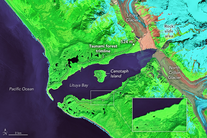
Modern photographs show forest returning to the slopes that Miller photographed almost bare. The bay still has its narrow entrance, Cenotaph Island, the glaciers and the steep mountains around the head. The wave’s trimline has become less visually violent as vegetation has returned, although the event remains written into the age and structure of the forest.
The boats are gone.
Sunmore never came back.
Badger sank outside the bay.
Edrie survived the night.
The number 1,720 survived all of them and became the thing most people know.
I think the treetops are more useful.
Bill Swanson was still on his boat when he looked down at them.
Sources & Further Reading
- Don J. Miller, U.S. Geological Survey, Giant Waves in Lituya Bay, Alaska (Professional Paper 354-C, 1960). The foundational primary technical source for runup measurements, boat positions, survivor evidence, earlier trimlines and physical mapping.
- Don Tocher and Don J. Miller, “Field Observations on Effects of Alaska Earthquake of 10 July 1958.” Near-contemporary scientific reporting on Fairweather Fault displacement and the extraordinary runup.
- Alaska Earthquake Center, “60 Years Ago: The 1958 Earthquake and Lituya Bay Megatsunami.” Particularly valuable for the Swanson, Ulrich and Wagner narratives, Miller’s field work and later research history.
- U.S. Geological Survey, “How Do Landslides Cause Tsunamis?” Current institutional language distinguishing the 524-meter runup from the roughly 30-meter wave moving through the bay.
- Weiss et al., Geophysical Research Letters, “Hybrid Modeling of the Mega-Tsunami Runup in Lituya Bay after Half a Century.” Modern physical-modeling work on the 524-meter runup.
- Franco et al., Natural Hazards and Earth System Sciences, “The 1958 Lituya Bay Tsunami.” Modern three-dimensional modeling of landslide geometry, bathymetry and wave propagation.
- U.S. Geological Survey, 2025 Tracy Arm Landslide-Generated Tsunami event record. Current evidence that extreme landslide-tsunami runup remains an active Alaskan hazard; its 470–500-meter estimate is explicitly preliminary.